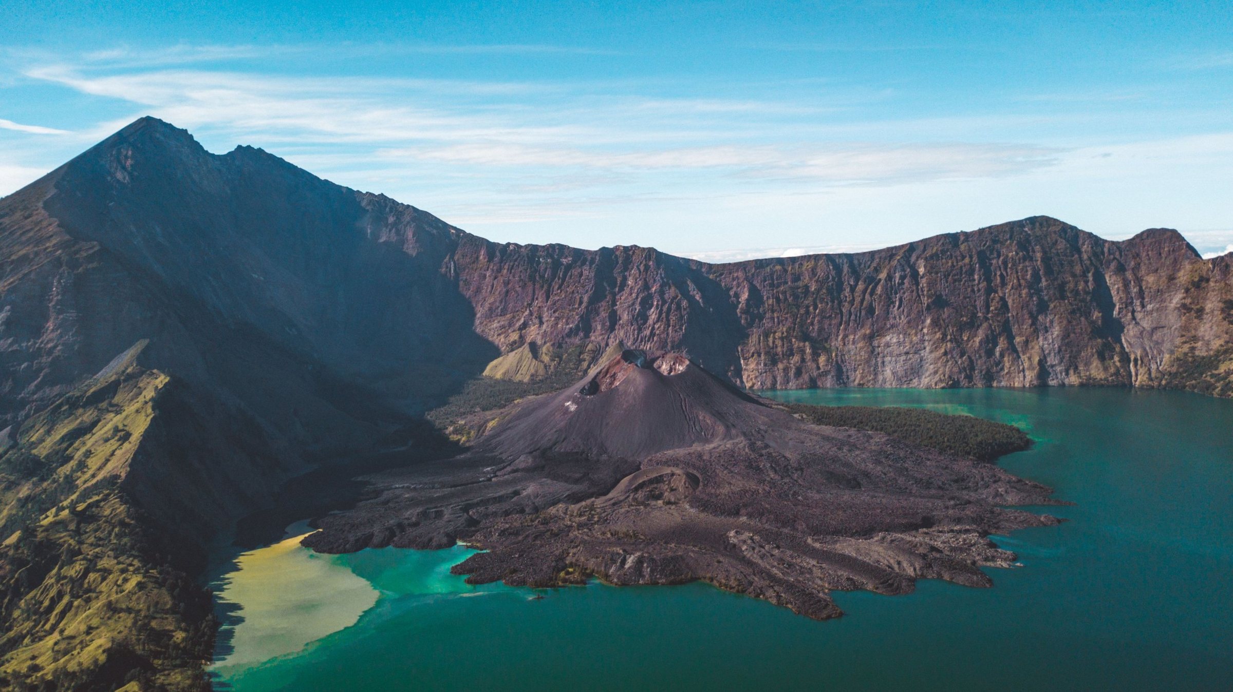
Northern Lombok is one mountain. Rinjani climbs from rice fields and forest to 3,726 metres, and inside its caldera lies a crescent lake left by one of the largest eruptions of the past two thousand years. Sacred to the Sasak and to Lombok's Hindus, it is also a serious climb with some of the strictest rules of any Indonesian mountain.
What is Gunung Rinjani National Park?
Gunung Rinjani National Park (Taman Nasional Gunung Rinjani) protects the volcano that fills northern Lombok, in the province of West Nusa Tenggara. Established in 1997, it covers 41,330 hectares, with tens of thousands more hectares of protected forest around its edges. In April 2018 UNESCO named the wider Rinjani-Lombok area a Global Geopark, and in April 2026 the geopark kept that status with a second green card at revalidation.
At its centre stands Gunung Rinjani, 3,726 metres high and the second-highest volcano in Indonesia after Kerinci on Sumatra. Its slopes reach into four regencies: North, West, Central and East Lombok. The park is managed by Balai TNGR, the national park office in Mataram, which sets the quotas, the rules and the opening dates.
The mountain shapes far more than the view. Its forests feed the springs and rivers that water much of Lombok's farmland, and in 2013 scientists described a bird found nowhere else: the Rinjani scops owl, known locally as burung pok after its call, which lives in forest and wooded farmland around the park.
How was the Rinjani caldera formed?
The caldera is the scar of a vanished mountain called Samalas, which once stood beside Rinjani and probably rose to about 4,200 metres. In 1257 it erupted with enormous force and then collapsed into its emptied magma chamber, leaving the oval basin, about 6 by 8.5 kilometres, that now holds the lake.
For decades, sulphate in Greenland and Antarctic ice cores pointed to a huge mid-13th-century eruption with no known source. In 2013 a team led by Franck Lavigne of Pantheon-Sorbonne University matched the ice-core signal to deposits on Lombok. The sulphate spike is about twice that of Tambora in 1815, and the eruption column is estimated to have reached around 40 kilometres. The Babad Lombok, palm-leaf chronicles written in Old Javanese, describe houses swept into the sea and the destruction of Pamatan, the royal capital of the time, which may still lie buried under the ash.
What is Segara Anak lake?
Segara Anak, "child of the sea", is the crater lake in the western half of the caldera, at about 2,000 metres above sea level and up to about 230 metres deep. It is the natural midpoint of most treks, a place to camp, fish and soak in the hot springs that feed pools near the shore.
On its eastern side rises Gunung Barujari, a young cone whose growth gives the lake its crescent shape. Every recorded eruption in modern times has come from Barujari. In late 2015 its lava flows reached the lake, and a small explosive eruption in September 2016 is the most recent listed by the Smithsonian's Global Volcanism Program.
Which Rinjani trekking routes are open?
As of October 2026, five official routes are open: Sembalun, Senaru, Timbanuh, Tetebatu and Aik Berik. The sixth, Torean, closed on 23 September 2026 after a forest fire around Bukit Setampol and should be treated as closed until the park announces otherwise. All routes are booked through eRinjani, the park's official app.
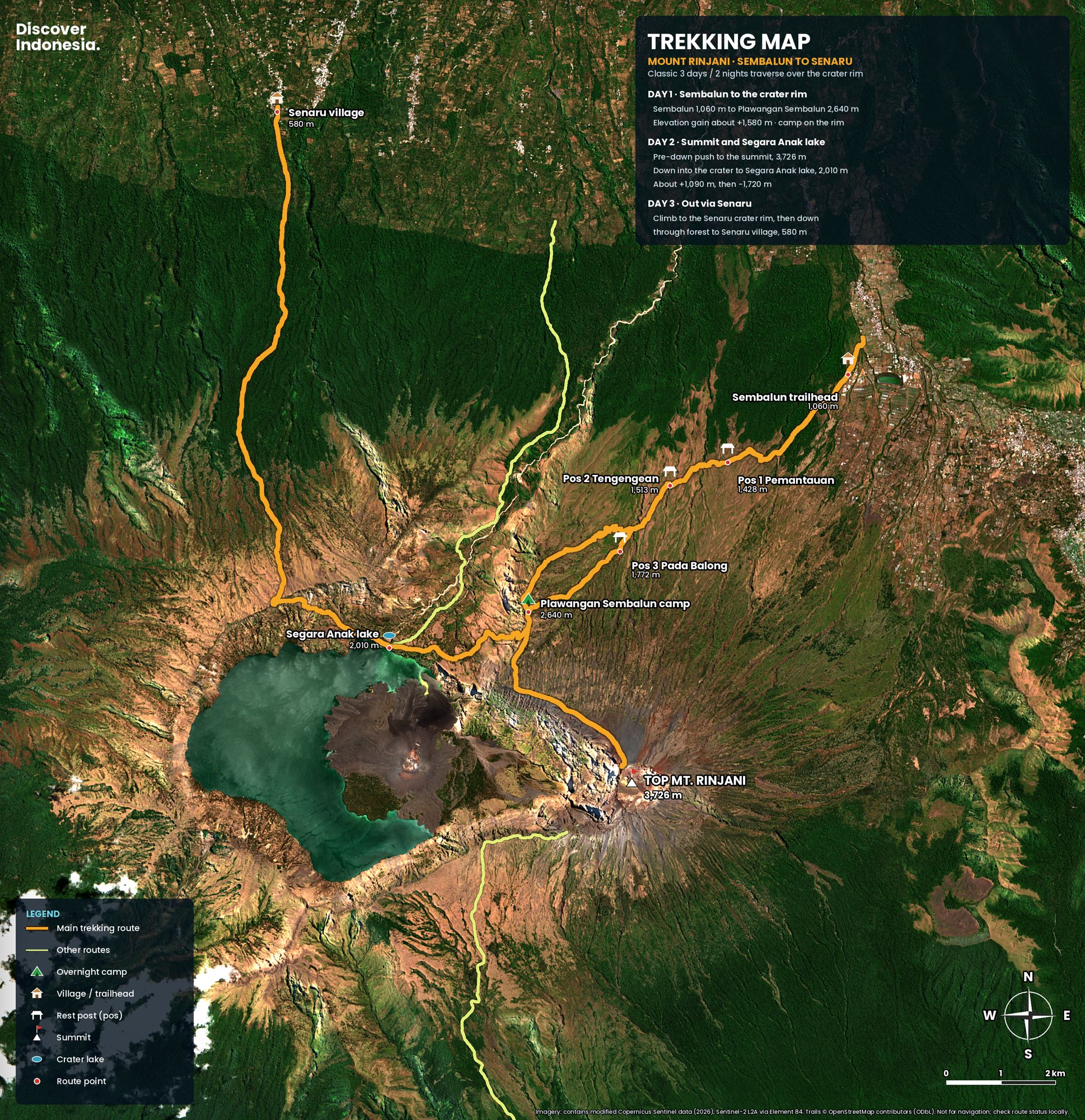
Sembalun, on the eastern side, starts high, crosses open grassland and leads to the Plawangan Sembalun rim camp, at about 2,640 metres, directly below the summit. Senaru, in the north, climbs from about 600 metres through tall forest to a rim above the lake and has no direct summit approach, which is why most people go up from Sembalun and come down through Senaru. Timbanuh, Tetebatu and Aik Berik approach from the south; they are quieter, and the park treats Aik Berik as an education route.
A typical crossing takes three days. Day one climbs to the Sembalun rim. Day two begins around 2 a.m. with a push of three to four hours, much of it on loose scree, to watch sunrise from the summit, then descends to the lake and hot springs. Day three climbs out to the Senaru rim and drops through the forest to the village. Four-day trips add a slower day at the lake, while two-day trips usually go only to the crater rim.
Map
Rinjani: the Sembalun and Senaru routes
Why is Rinjani sacred to the Sasak?
For many Sasak, Lombok's main people, Rinjani is the centre of their world and a bridge between the human and the divine. The mountain is said to be ruled by Dewi Anjani, a queen of the spirit world whose name it carries, and guides and porters still talk of her near the hot springs. Traditional leaders from Sembalun climb to make offerings for protection, water and good harvests.
Bayan, in the northern foothills near Senaru, is the heartland of Wetu Telu, a local form of Islam woven with older traditions. Lombok's Hindu community holds Segara Anak sacred too. Before the rainy season they carry offerings to the lake for Mulang Pekelem, a thanksgiving and prayer for rain, giving the water small figures of gold, silver and copper shaped as fish, shrimp and turtles. If you meet a ceremony at the lake, keep your distance, keep quiet and ask before taking photographs.
When is the best time to climb Rinjani?
Climb between April and December, ideally from July to September, when the weather is driest and clearest. Every year the park closes all routes during the rainy season; for 2026 the closure ran from 1 January to 31 March, with trails reopening on 1 April. Expect the same pattern in 2027 and check the dates before booking.
July and August are the busiest months and quotas can fill early, so September is often the best balance. November and December bring more rain and cloud. The dry season is also fire season: in September 2026 bookings were paused for a month and two routes closed after fires burned more than 1,000 hectares. Keep your dates flexible and choose an operator that explains what happens if a route closes.
How do you get to Mount Rinjani?
Fly to Lombok International Airport near Praya, about 40 minutes from Bali, then drive three to five hours to Sembalun or Senaru. Most trekking operators include the transfer.
Fast boats from Bali to Bangsal on the northwest coast take roughly two and a half to three and a half hours, and Senaru is about two hours' drive from there. Schedules change with the season, so check them before you book. Sleep the night before in Sembalun Lawang or Senaru rather than driving through the night. In Sembalun the park also requires a rest and health check before you start.
What does it cost to climb Rinjani, and what are the rules?
Since 3 November 2025, foreign trekkers pay a park fee of around IDR 150,000 to 250,000 per day, against IDR 20,000 to 75,000 for Indonesians. The fee is only part of the cost: guides, porters, food, tents and transfers are usually sold as a package by a licensed operator, and prices vary widely. Check the current fees in eRinjani before you go.
Since the safety review of 2025, every climber needs a health certificate from a clinic the day before the trek and insurance that covers the climb, mandatory since 1 October 2025. The park grades Rinjani as a Grade 4 mountain, not for beginners, and may ask for photos or a certificate from an earlier, easier climb. Anyone without that experience, and anyone under 17, must climb with a certified guide. A guide may lead at most five climbers, with a tighter limit of four announced for 2026, and porters are assigned at roughly one for every two to three trekkers. Everyone attends a safety briefing, and operators must check for warm clothing, sleeping bags and first aid.
Daily numbers are capped on each route. Choose an operator that books through eRinjani, ask exactly what the price includes, and ask how its porters are equipped and paid. Unusually cheap trips usually save on exactly that.
Is it safe to climb Rinjani?
Yes, with a certified guide, proper gear and the willingness to turn back, but it is not a casual hike. The summit ridge is steep, loose and exposed, cloud can close in quickly, and nights at the rim can fall to a few degrees above freezing.
In June 2025 Juliana Marins, a 26-year-old Brazilian, fell from the trail on the way to the summit, and her body was recovered only four days later. After further accidents in August, which caused another death and several injuries, the park closed routes for a safety review and reopened them in September with the rules above. Earlier, the July 2018 earthquake triggered landslides that stranded more than 500 hikers and guides in the caldera until they were evacuated.
Stay with your guide on the summit ridge, take the descent slowly, since many falls happen on the way down, and check the volcano's alert level on MAGMA Indonesia before you go. Indonesia's emergency number is 112.
How to visit Rinjani responsibly
Rinjani is the park office's pilot for a zero-waste national park. Single-use plastic, speakers and open fires are banned, and everything carried up must come back down. Pay the park fee through eRinjani, hire local guides and porters and treat them well, stay on the trail, never light fires in the dry season, and respect the lake as a sacred place, not only a campsite.
