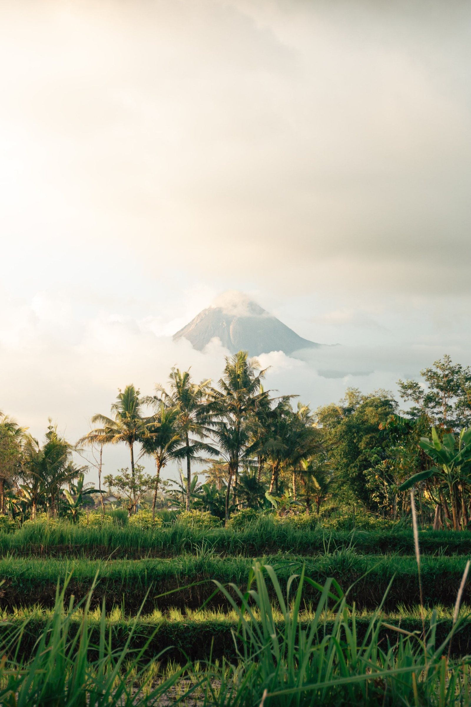
Merapi rises about 30 kilometres north of Yogyakarta, and on a clear morning it fills the city's northern skyline. The national park around it protects the forests on its flanks, but the volcano sets the rules: the summit has been closed for years, and what visitors see instead are the valleys its 2010 eruption buried.
What is Gunung Merapi National Park?
Gunung Merapi National Park (Taman Nasional Gunung Merapi, or TNGM) is a protected area of about 6,410 hectares around Mount Merapi, one of Indonesia's most active volcanoes. It was created in 2004, when a Ministry of Forestry decree (No. 134/Menhut-II/2004) turned the mountain's protected and production forests into a national park. It straddles two provinces: the regencies of Magelang, Boyolali and Klaten in Central Java, and Sleman in the Special Region of Yogyakarta.
It is a small park with a very large neighbour. Villages and farms climb high up every side of the mountain, and the park boundary often runs just above the last fields. The forests that survive on the middle slopes shelter birds of prey: park staff have reported Javan hawk-eagles, Indonesia's national bird, on the Boyolali side, along with black eagles and crested serpent eagles. Since 2009 local groups have worked with the park to replant native trees on slopes damaged by eruptions and sand mining.
Why is Merapi one of the most active volcanoes in Indonesia?
Merapi is a young stratovolcano fed by thick, sticky magma that builds lava domes at the summit instead of flowing away. When a dome grows unstable, parts of it collapse into glowing avalanches of rock and gas called pyroclastic flows, and this happens every few years. The Smithsonian Global Volcanism Program describes it as the youngest peak in a volcanic chain running north toward Ungaran.
Volcanologists even name a type of flow after it, the Merapi-type nuée ardente. Villagers call it wedhus gembel, the shaggy goat, after the way the grey clouds roll down the valleys. Such flows killed more than a thousand people in 1930 and struck again in 1994 and 2006.
The current eruption began in late December 2020 and is still going. In October 2026 BPPTKG, the agency that monitors Merapi, reported the southwest dome at about 4.18 million cubic metres, with lava avalanches sliding up to about 2 kilometres down the Krasak and other channels on most days.
What happened in the 2010 Merapi eruption?
The 2010 eruption was Merapi's largest since 1872. It began at 17:02 on 26 October, peaked on the night of 4 to 5 November, and killed 386 people according to the final count by BNPB, Indonesia's disaster agency. Nearly 350,000 people were evacuated and more than 2,000 homes destroyed.
Early tallies of around 340 dead are still often quoted. The exclusion zone grew in stages from 10 to 15 and then 20 kilometres, and the USGS credits the forecasts by Indonesian scientists with saving more than 10,000 lives, possibly more than 20,000. Pyroclastic flows ran far down the valleys of the southern slope, burning and burying hamlets such as Kinahrejo. Those same valleys are now the route of the lava tour.
Can you climb Mount Merapi in 2026?
No. As of October 2026 every climbing route on Merapi is closed, and the park office says climbing is not recommended for anyone. The trails have been shut since May 2018, and the volcano has stayed at Level III (Siaga), the second-highest of four, since 5 November 2020.
BPPTKG confirmed Level III again in mid-October 2026, after the MAGMA Indonesia app briefly showed Level I; the agency called that an error, so check more than one official channel. The old Selo route on the north side runs straight through the danger zone. When a rumour that it had reopened drew illegal climbers in July 2026, the park head stated that all routes remain closed and that park staff stay on standby at Selo. Do not book anyone offering a quiet summit climb.
What is the Merapi lava tour?
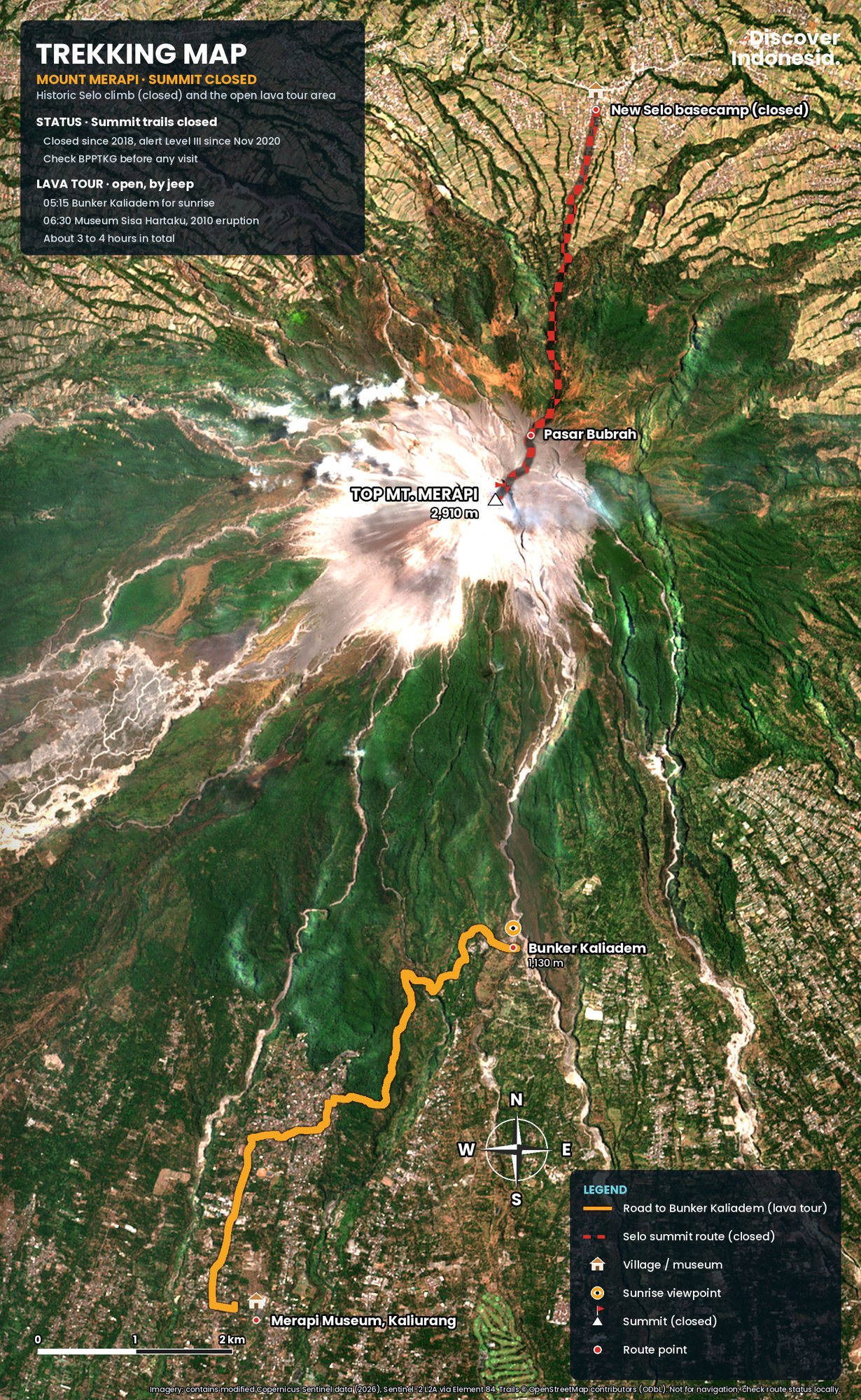
The lava tour is a ride in an open four-wheel-drive jeep across the southern slopes buried in 2010, starting from basecamps around Kaliurang and Cangkringan in Sleman, about an hour north of Yogyakarta. Jeeps take up to four people and are priced per jeep. Tours run from about 90 minutes to three and a half hours, and sunrise departures leave around 04:30.
The stops have real stories. Bunker Kaliadem, usually the highest point the jeeps reach, was built as a refuge from hot clouds; a flow buried it in June 2006 and two volunteers sheltering inside died. Today it is the classic sunrise stop, with the summit straight ahead. Museum Sisa Hartaku, "the remains of my treasures", is a house in Kepuharjo filled with what the flows left: animal skeletons, motorbike frames and a half-melted clock.
Most routes also pass Batu Alien, a boulder carried down in 2010, and Mbah Maridjan's former home in Kinahrejo, now a small memorial. Many end by splashing through the Kali Kuning river, a channel operators skip after heavy rain because it also carries lahars. The medium-length route is the sensible minimum, because it includes both Kaliadem and Kinahrejo.
Map
Merapi: the lava tour area
What else is there to see around Merapi?
Beyond the jeep tour, the main sights are the hill town of Kaliurang, the Merapi Museum and the viewpoint at Ketep Pass.
Kaliurang sits at about 900 metres, 28 kilometres north of central Yogyakarta, and grew from a colonial-era hill retreat. Inside the park, short walks lead to the Tlogo Putri pool and the Tlogo Muncar waterfall, which runs strongest after the rains. In town, the Ullen Sentalu museum covers Javanese court culture and the princesses of Yogyakarta and Surakarta, and the Pesanggrahan Ngeksigondo, a palace guesthouse, hosted diplomatic talks during the independence struggle.
The Merapi Museum (Museum Gunungapi Merapi), opened in 2009 on the road up to Kaliurang in Pakem, explains the volcano's geology, eruption history and monitoring, with an eruption simulation and a motorbike wrecked at Kaliadem in 2006. Recent listings show it closed on Mondays, so confirm locally. On the Magelang side, Ketep Pass at about 1,200 metres looks onto Merapi's summit and across to Merbabu, Sindoro and Sumbing on a clear morning.
What does Merapi mean to the Javanese?
For many Javanese, Merapi is a kingdom of spirits as well as a volcano. The Yogyakarta palace sits on a symbolic line between the mountain and the Southern Ocean, and each year it sends labuhan offerings up the slope, carried in procession from Kinahrejo and led by the mountain's appointed guardian.
From 1982 the guardian was Mbah Maridjan. When the 2010 eruption began he refused to leave Kinahrejo, about five kilometres from the peak, saying it was his duty to stay. He was found in his burnt house in a position of prayer, aged 83, and several people who had come to persuade him to leave died with him. Kinahrejo and the memorials are places of mourning: dress modestly and keep voices low.
When is the best time to visit Merapi?
Go in the dry season, roughly May to September, and go early. The summit is usually clearest from dawn until about 10:00, after which cloud often hides it. From November to March the mountain is often hidden and heavy rain can send lahars down the river channels.
Whatever the month, the volcano decides what is open. The park closes its nature sites on some holidays, such as Nyepi in March 2026, and closes them at short notice when activity rises. Book jeeps ahead for holiday weekends, when Yogyakarta fills with domestic visitors.
How do you get to Merapi, and what does it cost?
Fly into Yogyakarta International Airport (YIA) or arrive by train, then take a jeep package with hotel pick-up or a car and driver to the basecamps; there is no useful public transport to the tour sites. Sleeping in Kaliurang cuts the pre-dawn drive to minutes. Check flight and train schedules before you book.
Merapi pairs naturally with the temples, both UNESCO World Heritage Sites since 1991. Prambanan is the easier drive from Cangkringan for the late light after a sunrise tour; keep Borobudur, about 40 kilometres northwest of the city, for another morning, with Ketep Pass on the way back.
For the park's nature sites, such as Tlogo Muncar, Kaliurang Park and Plunyon, the park's holiday rate in March 2026 was IDR 150,000 per foreign visitor per day and IDR 15,000 for Indonesians. Lava tour jeeps were advertised from around IDR 350,000 per jeep in 2025, rising with the length of the route, and Sisa Hartaku runs on donations. Prices change, so check before you go.
Is it safe to visit Merapi?
The lower slopes are reasonably safe with a licensed operator who follows BPPTKG's danger zones, but they are not risk-free. The current recommendation keeps everyone out of a 3-kilometre radius around the summit and out of the river valleys where flows could reach: up to 5 kilometres along the Boyong, 7 along the Bedog, Krasak and Bebeng, 3 along the Woro and 5 along the Gendol.
Check BPPTKG's daily report and MAGMA Indonesia the day before, never cross a barrier, and respect lahar warnings, since rain upstream can send mudflows down a dry channel with little warning. The everyday risks are the open jeep and the river crossing, so hold on and bring closed shoes, a buff against dust and a light jacket for sunrise.
Travel responsibly here: pay the park fees, hire local jeep crews and guides, and buy food and drinks in the villages that rebuilt after 2010. Stay on the tracks, take your rubbish back down, and ask before photographing people at memorials.
